


PERRYSBURG TWP FT MEIGS Voting District, Wood County, Ohio
About
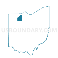
Outline

Summary
| Unique Area Identifier | 653412 |
| Name | PERRYSBURG TWP FT MEIGS Voting District |
| County | Wood County |
| State | Ohio |
| Area (square miles) | 2.29 |
| Land Area (square miles) | 2.14 |
| Water Area (square miles) | 0.15 |
| % of Land Area | 93.54 |
| % of Water Area | 6.46 |
| Latitude of the Internal Point | 41.52632020 |
| Longtitude of the Internal Point | -83.67720070 |
Maps


Graphs
Select a template below for downloading or customizing gragh for PERRYSBURG TWP FT MEIGS Voting District, Wood County, Ohio


Neighbors
Neighoring Voting District (by Name) Neighboring Voting District on the Map
- MAUMEE 1 Voting District, Lucas County, OH
- MAUMEE 3 Voting District, Lucas County, OH
- MIDDLETON TWP NORTH Voting District, Wood County, OH
- PERRYSBURG B Voting District, Wood County, OH
- PERRYSBURG G Voting District, Wood County, OH
- PERRYSBURG I Voting District, Wood County, OH
- PERRYSBURG L Voting District, Wood County, OH
- PERRYSBURG TWP NORTH Voting District, Wood County, OH
- PERRYSBURG U Voting District, Wood County, OH
- PERRYSBURG V Voting District, Wood County, OH
- PERRYSBURG W Voting District, Wood County, OH
- PERRYSBURG X Voting District, Wood County, OH
- PERRYSBURG Y Voting District, Wood County, OH
- WATERVILLE 7 Voting District, Lucas County, OH
Top 10 Neighboring County Subdivision (by Population) Neighboring County Subdivision on the Map
- Perrysburg city, Wood County, OH (20,623)
- Maumee city, Lucas County, OH (14,286)
- Perrysburg township, Wood County, OH (12,512)
- Monclova township, Lucas County, OH (12,400)
- Waterville township, Lucas County, OH (11,336)
- Middleton township, Wood County, OH (4,454)
Top 10 Neighboring Place (by Population) Neighboring Place on the Map
Top 10 Neighboring Unified School District (by Population) Neighboring Unified School District on the Map
- Anthony Wayne Local School District, OH (27,810)
- Perrysburg Exempted Village School District, OH (26,921)
- Maumee City School District, OH (17,928)
Top 10 Neighboring State Legislative District Lower Chamber (by Population) Neighboring State Legislative District Lower Chamber on the Map
Top 10 Neighboring State Legislative District Upper Chamber (by Population) Neighboring State Legislative District Upper Chamber on the Map
Top 10 Neighboring 111th Congressional District (by Population) Neighboring 111th Congressional District on the Map
Top 10 Neighboring Census Tract (by Population) Neighboring Census Tract on the Map
- Census Tract 90, Lucas County, OH (12,417)
- Census Tract 206.02, Wood County, OH (6,894)
- Census Tract 207, Wood County, OH (6,533)
- Census Tract 89.02, Lucas County, OH (6,125)
- Census Tract 212, Wood County, OH (5,555)
- Census Tract 206.01, Wood County, OH (4,175)
- Census Tract 71.02, Lucas County, OH (3,812)
- Census Tract 205, Wood County, OH (2,295)